A while ago we introduced the 1880
Bromley Brooklyn Atlas, which color-codes structures by building type: pink for brick, yellow for wood.
The excerpt below shows that development in the northwest Slope was well advanced by 1880. The excerpt shows 5th Avenue to the left, 6th Avenue to the right, Flatbush Avenue on the diagonal at the top, and Bergen, St. Marks, and Prospect Place from top to bottom.
 1880 Bromley Brooklyn Atlas showing NW Park Slope
 Prospect Place between 5th & 6th Avenues, north side, circa 1870s -
unprotected
 1880 Bromley Brooklyn Atlas showing NW Park Slope
 Prospect Place between 5th & 6th Avenues, north side, circa 1870s -
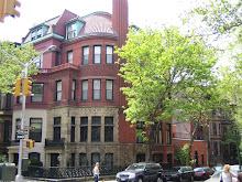
No comments:
Post a Comment